Late Victorian Wellington comes to life in a new book based around the famous Thomas Ward maps. Jane O’Loughlin talked to the author.
Have you ever wondered how your house looked in 1898? Are you curious about the materials used for the roof, or whether it featured bay windows?
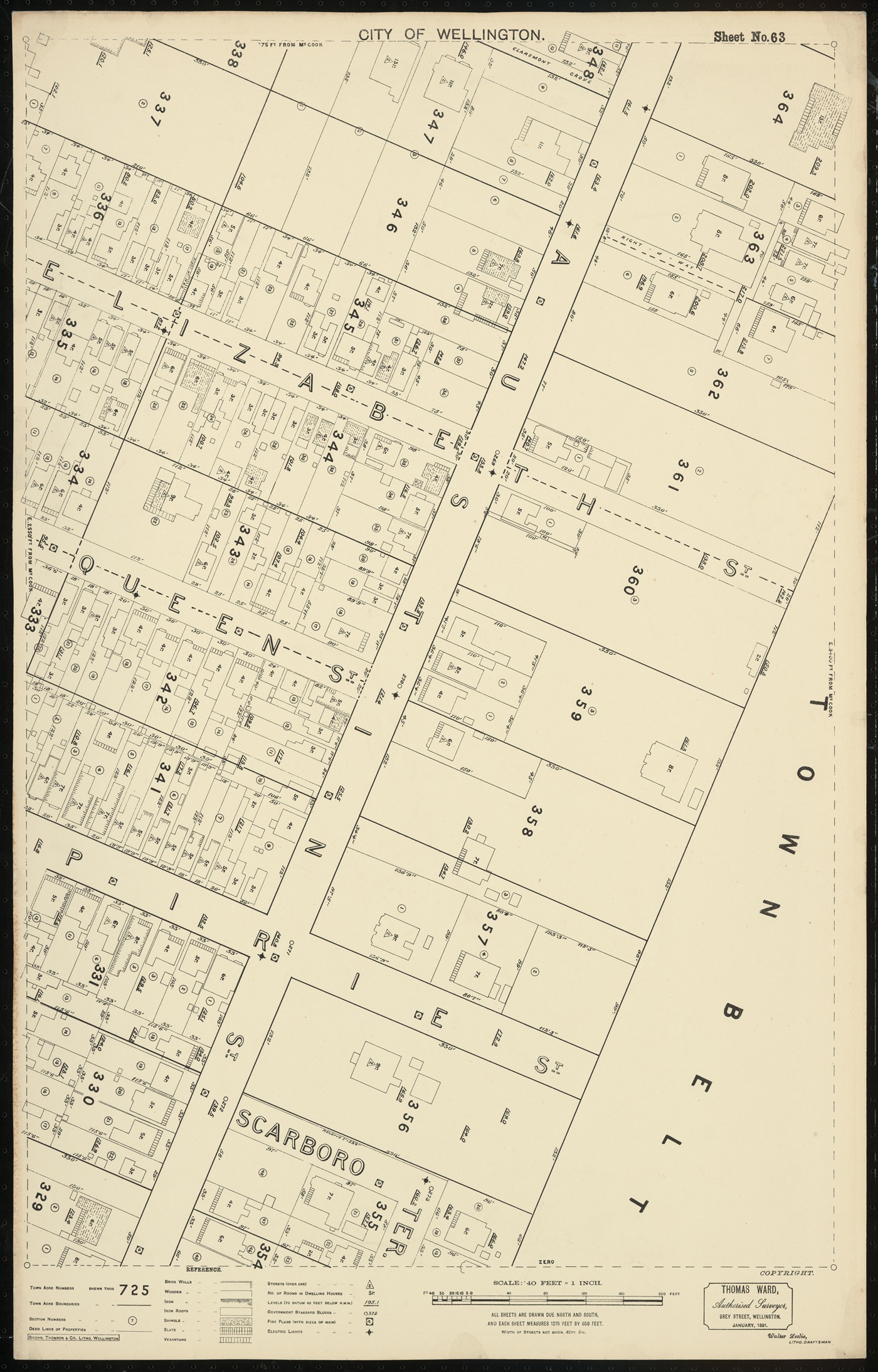
You may find the answers in the Thomas Ward maps, an extraordinary resource that details the geography and architecture of late Victorian Wellington. Historian Elizabeth Cox, has used these maps as the foundation for a book of social history, focusing on the 1890s—a period of significant change for the city. Cox’s interests in Wellington history, women’s history, and architectural history all converge in her new book, Mr Ward’s Map.
Her book includes all 88 maps, which cover Wellington’s inner-city suburbs within the town belt—where most Wellingtonians lived until the advent of the motor car around the turn of the century allowed residents to move further afield. Thomas Ward, originally from Oxford in the United Kingdom, worked as an engineer in Wellington.
According to Cox, Ward was troubled by the lack of a comprehensive map of Wellington. He contacted the council and offered to create an accurate map of the city. Initially, his proposal was for a simple map of legal titles. “But while he was working on it, he had another idea: he offered to draw every single building in the city,” says Cox.
“He drew every commercial building, every house, every outdoor toilet, every outdoor shed, and all the legal titles, every street light…and all the fire hydrants. “Not only did he draw the footprint for every building, but for each house he recorded how many rooms there were - not bedrooms, but rooms, total. And he noted what the walls were made of and what the roof was made of, and he drew every verandah and every bay window.”
For the next ten years, Ward held a series of rolling contracts to keep the maps up to date. He faced a considerable challenge, as the city was rapidly growing with many new developments and subdivisions.
Updates included details such as changes in roofing materials, as homeowners switched from wooden tiles to corrugated iron to reduce fire risk. “So someone went along and actually wrote ‘cast iron’ on every house where somebody had changed the roof. It was that level of detail.”
Although Cox was initially drawn to Ward’s first ‘pristine’ maps, she chose to use images of the later, updated maps for her book, as they better illustrate the pace of change in Wellington’s suburbs.
Cox uses the maps as a starting point to tell stories about the social history of the people who lived and worked in the houses and buildings. This includes stories about early Mt Victoria, which was being transformed by new subdivisions at the time. Cox notes that houses in Mt Victoria were not built by the wealthy gentry, but by well-earning tradespeople.
In one Mt Victoria story, Cox investigates the work of early suffragettes. Through research, she reconstructed the likely journey a petition collector took up and down Mt Victoria’s streets, gathering signatures. Another story examines a devastating fire on Hawker Street.
To help fund the book, Cox is selling prints of the maps. This has become another source of information, as people have been eager to learn about their homes and share their own stories with her. She has enjoyed helping people choose their map and discussing their houses with them.
The book, which is released in November is substantial - at 2.5 kilos it makes a hefty and impressive potential Christmas gift for any person interested in Wellington’s history.
Elizabeth Cox will be speaking about her book at a talk for the Mt Victoria Historical Society on 23 November 2025.