


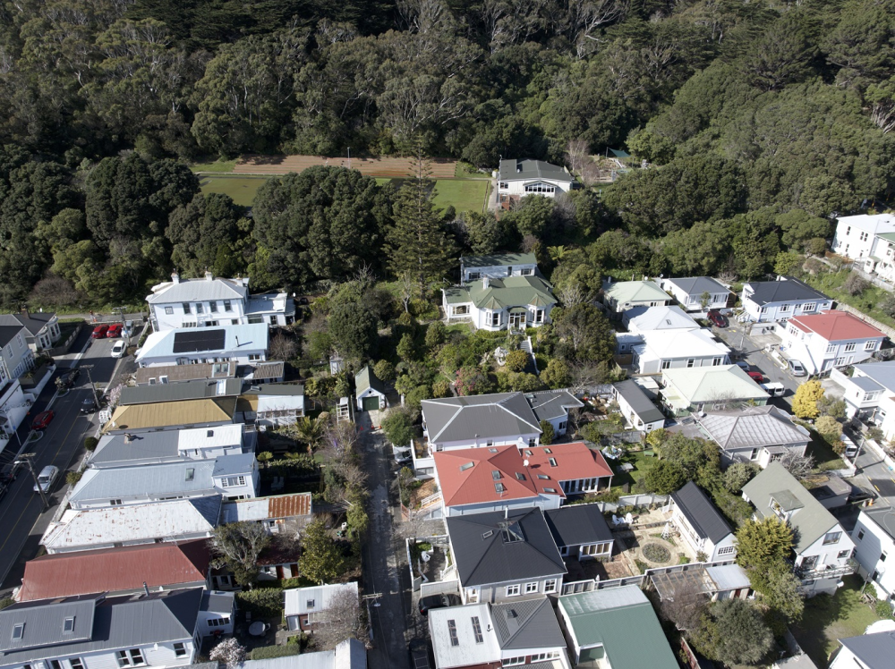
Drone photographs of the Mt Victoria suburb demonstrate the prominence of the Westbourne estate, off Austin Street, destined to be turned into multistorey apartments.
The house (the white house with the green roof, surrounded by trees) is elevated above much of the surrounding houses, which are only one or two storeys high.
The controversial proposal has many neighbours worried about the effects of shading and increased traffic, and seeking legal advice on their options.
A local resident and film student, Phil Kelliher, is following the story and sent a drone up to get a better look at the site, which is hard to see from the street.
Aerial footage reveals how significant the Westbourne site is, Kelliher says.
“It’s a really large site, but you don’t realise that from the street, because of the trees surrounding the house and the townbelt behind it,” says Kelliher, who sought permission from neighbours to send a drone up to take aerial photos.
“Once the trees are gone and the development starts, it will become obvious. A six-storey apartment block is really going to dominate the neighbourhood, shade surrounding houses and wall off the town belt from many,” he said.
Developers Forma Group are in the process of designing a ‘high end residential’ development dubbed the ‘Mayfair’ on the 1,473 square metre estate.
Plans for the new development are not yet available but it is expected to be around six storeys high.
Most of Mt Victoria is now zoned for six storey buildings under Wellington’s new District Plan, except for those areas designated as heritage or character.
Neighbours and the council need to understand the impact of the development says Kelliher.
“I’ve decided to document this local story in order to get more people interested in what’s happening in our neighbourhood and what we may lose.
“With new high density rules now in place, we will be seeing more of this kind of development. It would be possible to build high rises in some areas of Mt Victoria in a way that doesn’t affect existing residents too much, but due to the topography this development is likely to be out of scale and out of place.”
A documentary is being produced as part of Kelliher's film course at Victoria University of Wellington.


Aerial footage reveals how significant the Westbourne site is.